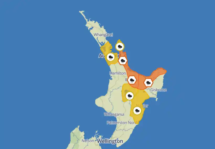
The Metservice has issued a number of weather advisories for the upper North Island today.
More heavy rain is expected to hit flood-affected Auckland late this afternoon and into Monday morning.
Metservice Severe Weather Warnings
Further heavy rain for parts of the North Island
A strong and humid northeast flow remains over northern and central New Zealand. Bursts of heavy rain are likely in a number of regions, along with strong to gale force winds. Thunderstorms and localised downpours are also possible in some places. People are advised to keep up to date with forecasts in case any changes are made, or further areas are added.
Heavy Rain Warning
Heavy rain may cause streams and rivers to rise rapidly. Surface flooding and slips are also possible and driving conditions may be hazardous.
- Area: Coromandel Peninsula
Period: 16hrs from 10pm Sat, 28 Jan – 2pm Sun, 29 Jan
Forecast: Expect 80 to 120 mm of rain, with the largest amounts likely about the ranges. These amounts are in addition to the rain that has already fallen. Peak intensities of 15 to 25 mm/h, but possibly 25 to 40 mm/h in thunderstorms bringing localised downpours. Note, showers are likely during Sunday afternoon and evening, and some could be heavy with thunderstorms also possible. - Area: Bay of Plenty from Kawerau westwards
Period: 15hrs from 8pm Sat, 28 Jan – 11am Sun, 29 Jan
Forecast: Expect 80 to 120 mm of rain in addition to what has already fallen. Peak intensities of 15 to 25 mm/h, but possibly 25 to 40 mm/h in thunderstorms bringing localised downpours. Note, showers are likely during Sunday afternoon and evening, and some could be heavy with thunderstorms also possible. - Area: Bay of Plenty east of Kawerau, and Gisborne north of Ruatoria
- Period: 4hrs from 8pm Sat, 28 Jan – midnight Sat, 28 Jan
- Forecast: Expect another 20 to 40 mm of rain, with the largest amounts likely about the ranges. Peak rates of 15 to 25 mm/h. Note, further rain or showers are expected on Sunday, which could be heavy at times with thunderstorms also possible.
Heavy Rain Watch
- Area: Auckland including Great Barrier Island
Period: 24hrs from 6am Sun, 29 Jan – 6am Mon, 30 Jan
Forecast: Showers are likely, but a period of heavy rain is possible during Sunday that may continue into Monday morning. Thunderstorms are also possible Sunday afternoon and evening. - Area: Taupo
Period: 15hrs from 8pm Sat, 28 Jan – 11am Sun, 29 Jan
Forecast: Periods of heavy rain, with thunderstorms possible. Rainfall amounts may approach warning criteria. - Area: Hawke’s Bay south of Wairoa
Period: 7hrs from 8pm Sat, 28 Jan – 3am Sun, 29 Jan
Forecast: Periods of heavy rain, and amounts may approach warning criteria.
For update-to-date weather information, visit Metservice.com.

Looks like Mayor Brown could be on thin ice?